MKGeodesicPolyline
We knew that the Earth was not flat long before 1492. Early navigators observed the way ships would dip out of view over the horizon many centuries before the Age of Discovery.
For many iOS developers, though, a flat MKMap
was a necessary conceit until recently.
What changed? The discovery of MKGeodesic
, which is the subject of this week’s article.
MKGeodesic
was introduced to the Map Kit framework in iOS 7. As its name implies, it creates a geodesic—essentially a straight line over a curved surface.
On the surface of a sphere oblate spheroid geoid, the shortest distance between two points appears as an arc on a flat projection. Over large distances, this takes a pronounced, circular shape.
An MKGeodesic
is created with an array of 2 MKMap
s or CLLocation
s:
MKGeodesicPolyline
Creating an let LAX = CLLocation(latitude: 33.9424955, longitude: -118.4080684)
let JFK = CLLocation(latitude: 40.6397511, longitude: -73.7789256)
var coordinates = [LAX.coordinate, JFK.coordinate]
let geodesicPolyline = MKGeodesicPolyline (coordinates: &coordinates, count: 2)
mapView .addOverlay (geodesicPolyline )
CLLocation *LAX = [[CLLocation alloc] initWithLatitude :33.9424955
longitude:-118.4080684];
CLLocation *JFK = [[CLLocation alloc] initWithLatitude :40.6397511
longitude:-73.7789256];
CLLocationCoordinate2D coordinates[2] =
{LAX.coordinate, JFK.coordinate};
MKGeodesicPolyline *geodesicPolyline =
[MKGeodesicPolyline polylineWithCoordinates :coordinates
count:2];
[mapView addOverlay :geodesicPolyline ];
Although the overlay looks like a smooth curve, it is actually comprised of thousands of tiny line segments (true to its MKPolyline
lineage):
print(geodesicPolyline .pointCount ) // 3984
NSLog(@"%d", geodesicPolyline .pointCount ) // 3984
Like any object conforming to the MKOverlay
protocol, an MKGeodesic
instance is displayed by adding it to an MKMap
with add
and implementing map
:
MKGeodesicPolyline
on an MKMapView
Rendering // MARK: MKMapViewDelegate
func mapView (mapView : MKMapView , rendererForOverlay overlay: MKOverlay) -> MKOverlayRenderer {
guard let polyline = overlay as? MKPolyline else {
return MKOverlayRenderer ()
}
let renderer = MKPolylineRenderer (polyline: polyline)
renderer.lineWidth = 3.0
renderer.alpha = 0.5
renderer.strokeColor = UIColor.blueColor ()
return renderer
}
#pragma mark - MKMapViewDelegate
- (MKOverlayRenderer *)mapView :(MKMapView *)mapView
rendererForOverlay :(id <MKOverlay>)overlay
{
if (![overlay isKindOfClass :[MKPolyline class]]) {
return nil;
}
MKPolylineRenderer *renderer =
[[MKPolylineRenderer alloc] initWithPolyline :(MKPolyline *)overlay];
renderer.lineWidth = 3.0f;
renderer.strokeColor = [UIColor blueColor ];
renderer.alpha = 0.5;
return renderer;
}
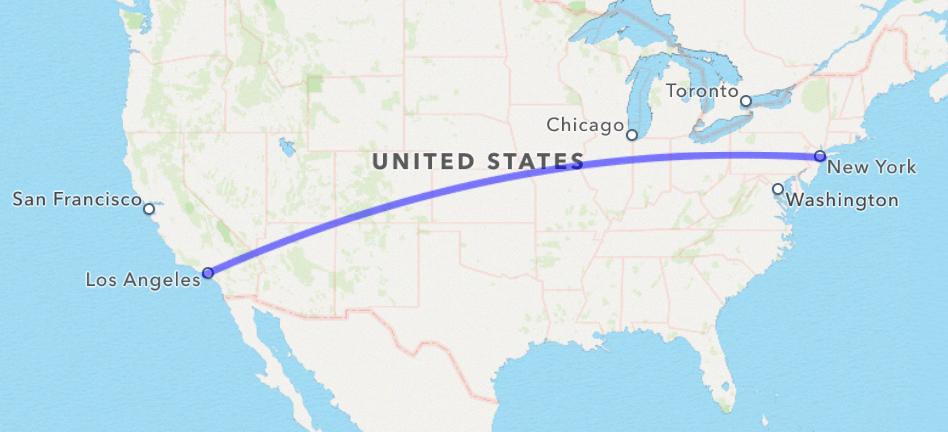
For comparison, here’s the same geodesic overlaid with a route created from
MKDirections
:
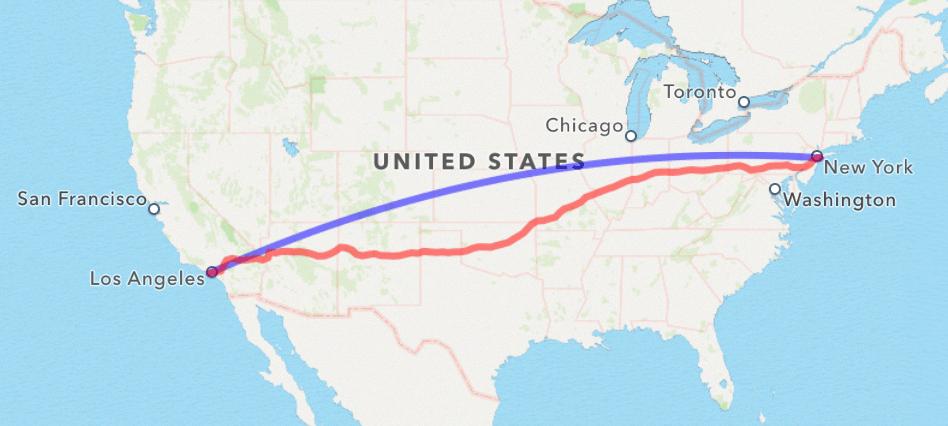
As the crow flies, it’s 3,983 km.
As the wolf runs, it’s 4,559 km—nearly 15% longer.
…and that’s just distance; taking into account average travel speed, the total time is ~5 hours by air and 40+ hours by land.
MKAnnotationView
on a MKGeodesicPolyline
Animating an Since geodesics make reasonable approximations for flight paths, a common use case would be to animate the trajectory of a flight over time.
To do this, we’ll make properties for our map view and geodesic polyline between LAX and JFK, and add new properties for the plane
and plane
(the index of the current map point for the polyline):
// MARK: Flight Path Properties
var mapView : MKMapView !
var flightpathPolyline : MKGeodesicPolyline !
var planeAnnotation : MKPointAnnotation !
var planeAnnotationPosition = 0
@interface MapViewController () <MKMapViewDelegate >
@property MKMapView *mapView ;
@property MKGeodesicPolyline *flightpathPolyline ;
@property MKPointAnnotation *planeAnnotation ;
@property NSUInteger planeAnnotationPosition ;
@end
Next, right below the initialization of our map view and polyline, we create an MKPoint
for our plane:
let annotation = MKPointAnnotation ()
annotation.title = NSLocalizedString ("Plane", comment: "Plane marker")
mapView .addAnnotation (annotation)
self.planeAnnotation = annotation
self.updatePlanePosition ()
self.planeAnnotation = [[MKPointAnnotation alloc] init];
self.planeAnnotation .title = NSLocalizedString (@"Plane", nil);
[self.mapView addAnnotation :self.planeAnnotation ];
[self updatePlanePosition ];
That call to update
in the last line ticks the animation and updates the position of the plane:
func updatePlanePosition () {
let step = 5
guard planeAnnotationPosition + step < flightpathPolyline .pointCount
else { return }
let points = flightpathPolyline .points()
self.planeAnnotationPosition += step
let nextMapPoint = points[planeAnnotationPosition ]
self.planeAnnotation .coordinate = MKCoordinateForMapPoint (nextMapPoint )
performSelector ("updatePlanePosition" , withObject : nil, afterDelay : 0.03)
}
- (void)updatePlanePosition {
static NSUInteger const step = 5;
if (self.planeAnnotationPosition + step >= self.flightpathPolyline .pointCount ) {
return;
}
self.planeAnnotationPosition += step;
MKMapPoint nextMapPoint = self.flightpathPolyline .points[self.planeAnnotationPosition ];
self.planeAnnotation .coordinate = MKCoordinateForMapPoint (nextMapPoint );
[self performSelector :@selector(updatePlanePosition ) withObject :nil afterDelay :0.03];
}
We’ll perform this method roughly 30 times a second, until the plane has arrived at its final destination.
Finally, we implement map
to have the annotation render on the map view:
func mapView (mapView : MKMapView , viewForAnnotation annotation: MKAnnotation) -> MKAnnotationView ? {
let planeIdentifier = "Plane"
let annotationView = mapView .dequeueReusableAnnotationViewWithIdentifier (planeIdentifier )
?? MKAnnotationView (annotation: annotation, reuseIdentifier : planeIdentifier )
annotationView .image = UIImage(named: "airplane")
return annotationView
}
- (MKAnnotationView *)mapView :(MKMapView *)mapView
viewForAnnotation :(id <MKAnnotation>)annotation
{
static NSString * PinIdentifier = @"Pin";
MKAnnotationView *annotationView = [mapView dequeueReusableAnnotationViewWithIdentifier :PinIdentifier ];
if (!annotationView ) {
annotationView = [[MKAnnotationView alloc] initWithAnnotation :annotation reuseIdentifier :PinIdentifier ];
}
annotationView .image = [UIImage imageNamed :@"plane"];
return annotationView ;
}
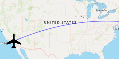
Hmm… close but no SkyMall Personalized Cigar Case Flask.
Let’s update the rotation of the plane as it moves across its flightpath.
MKAnnotationView
along a Path
Rotating an To calculate the plane’s direction, we’ll take the slope from the previous and next points:
let previousMapPoint = points[planeAnnotationPosition ]
planeAnnotationPosition += step
let nextMapPoint = points[planeAnnotationPosition ]
self.planeDirection = directionBetweenPoints (previousMapPoint , nextMapPoint )
self.planeAnnotation .coordinate = MKCoordinateForMapPoint (nextMapPoint )
MKMapPoint previousMapPoint = self.flightpathPolyline .points[self.planeAnnotationPosition ];
self.planeAnnotationPosition += step;
MKMapPoint nextMapPoint = self.flightpathPolyline .points[self.planeAnnotationPosition ];
self.planeDirection = XXDirectionBetweenPoints (previousMapPoint , nextMapPoint );
self.planeAnnotation .coordinate = MKCoordinateForMapPoint (nextMapPoint );
direction
is a function that returns a CLLocation
(0 – 360 degrees, where North = 0) given two MKMap
s.
We calculate from
MKMap
s rather than converted coordinates, because we’re interested in the slope of the line on the flat projection.Point
private func directionBetweenPoints (sourcePoint : MKMapPoint , _ destinationPoint : MKMapPoint ) -> CLLocationDirection {
let x = destinationPoint .x - sourcePoint .x
let y = destinationPoint .y - sourcePoint .y
return radiansToDegrees (atan2(y, x)) % 360 + 90
}
static CLLocationDirection XXDirectionBetweenPoints (MKMapPoint sourcePoint , MKMapPoint destinationPoint ) {
double x = destinationPoint .x - sourcePoint .x;
double y = destinationPoint .y - sourcePoint .y;
return fmod(XXRadiansToDegrees (atan2(y, x)), 360.0f) + 90.0f;
}
That convenience function radians
(and its partner, degrees
) are simply:
private func radiansToDegrees (radians: Double) -> Double {
return radians * 180 / M_PI
}
private func degreesToRadians (degrees: Double) -> Double {
return degrees * M_PI / 180
}
static inline double XXRadiansToDegrees (double radians) {
return radians * 180.0f / M_PI;
}
static inline double XXDegreesToRadians (double degrees) {
return degrees * M_PI / 180.0f;
}
That direction is stored in a new property, var plane
, calculated from self.plane
in update
(ideally renamed to update
with this addition). To make the annotation rotate, we apply a transform
on annotation
:
annotationView .transform = CGAffineTransformRotate (mapView .transform,
degreesToRadians (planeDirection ))
self.annotationView .transform =
CGAffineTransformRotate (self.mapView .transform,
XXDegreesToRadians (self.planeDirection ));
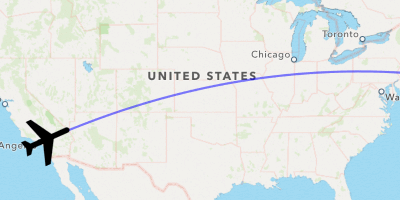
Ah much better! At last, we have mastered the skies with a fancy visualization, worthy of any travel-related app.
Perhaps more than any other system framework, MapKit has managed to get incrementally better, little by little with every iOS release [1] [2]. For anyone with a touch-and-go relationship to the framework, returning after a few releases is a delightful experience of discovery and rediscovery.
I look forward to seeing what lies on the horizon with iOS 8 and beyond.